An Introduction to Real Time Location Systems (RTLS)
Introduction
A Real Time Location System, better known as RTLS, denotes a group of systems that can determine a person or item’s exact or relative position. RTLS is not a specific type of system or technology but is a goal that can be achieved by different types of technology.
RTLS is frequently used in the healthcare industry due to the high importance of the items being tracked. In healthcare, knowing accurate, real-time locations of patients, staff, large medical equipment, or medical carts can make an impact in critical situations. In other industries, a well deployed RTLS can save money, time, or a combination of both. Other industries that commonly use RTLS include manufacturing, transportation, construction, agriculture, logistics, oil and gas, and mining.
Systems that can provide an asset’s Real Time Location are made up of a few different components, and the name of each varies depending on the technology. Below are the three most common groupings of components that make up an RTLS:
- Transponders – also called Tags, Beacons, or Smart Devices.
- Receivers – also called Readers, Location Sensors, Access Points, Beacons, or Smart Devices.
- Software – can be grouped as Firmware, Software, Application Software, or Middleware.
Technology and Coverage Options
Every system that provides Real Time Location data is unique because of the variety of applicable technologies, system parts, coverage options, and granularity it can offer.
Click Here to see the Full Size Infographic
The most common technologies used to create an RTLS are – Bluetooth Low Energy, GNSS (GPS), Infrared Radiation, Passive RFID, Active RFID, Ultrasound Radiation, Ultra-Wideband, Vision, and Wi-Fi. Other technologies are available with the capability of providing Real Time Location coverage, but these have been excluded due to being outdated, generally unpopular, or not cost-effective.
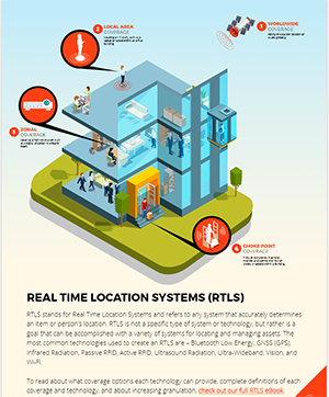
Coverage options available with an RTLS can be classified into a few broad categories, and each technology can provide one or more of these coverages. For instance, GNSS, commonly referred to as GPS, uses satellites to determine the exact location of an item or person based on latitude and longitude coordinates. Because GNSS technology can provide a location on a global scale, it is referred to as Wide Area/Worldwide Coverage.
The categories of RTLS coverage options available are:
- Wide Area Coverage
- Local Area Coverage
- Zonal Coverage
- Choke Points
Deciding the amount of coverage necessary for a potential system is a good place to start when determining the best RTLS for your needs.
To read about what coverage options each technology can provide, complete definitions of each coverage and technology, and about increasing granulation, check out the full eBook here.
Conclusion
If you would like to learn more about all things RFID, check out our website, our YouTube channel, comment below, or contact us.
To read more about different technologies, check out the links below!